Damages along the Californian coast have reached up to $50 million.
Scientists at the California Geological Survey (CGS) are visiting every port city along California's coast to detail the affects of the tsunami that hit the coast as a result of the March 11 earthquake in Japan.
Rick Wilson, and engineering geologist for the California Geological Survey has said, the CGS is now planning maps to help land-use planners assess hazards to buildings near shores and harbors as well as provide a guide to danger zones where new construction might be avoided. The new maps will not be ready for a year or two. The maps are primarily based on a worst case scenario of a 9.2 magnitude earthquake in the Aleutian Islands (Alaska).
Read more: http://www.sfgate.com/cgi-bin/article.cgi?=/c/a/2011/03/21/BAR51IG6NE.DTL#ixzz1HSC1rchY
New evacuations plans are also being developed for future tsunamis.
It is good to know that we are learning from this disastrous event so that we can be better prepared in the future.
Wednesday, March 23, 2011
We're Sinking....
Foundation and walls cracking....water leaking through windows....
These are a few signs that people whose houses are built on sinkholes are seeing in Florida. The land below their houses in sinking. Some home owners are saying that their house will sink in before it will be fixed. There is a major debate going the the Florida legislature right now to find out when insurance companies should pay for sinkhole damage. For more information about the insurance companies seeking legislation to reduce sinkhole claims click here.
What is a sinkhole?
A sinkhole is a hole or depression in the earth's surface often associated with glacial terrain. Sinkholes can vary in size from about 3 meters to 600 meters. They can form gradually or can occur suddenly in rocks that naturally be dissolved by water circulating through them. This creates voids in the rock that can cause the rock to collapse. Many processes can lead to sinkholes. Erosion, lowering the level of groundwater, or the collapsing of a cave can all lead to the formation of sinkholes.
Check out this video catching the some of a sinkhole collapsing in Texas in 2008.
Federal $ to Foreign aid
Recently I have been surfing the internet and have constantly been seeing links to donate to the people of Japan.
As a nation, should we be putting money into foreign humanitarian aid, when poverty and humanitarian issues exist at home? Has New Orleans been fully rebuilt?
How much should be spent aboard and where do you draw the line? In 2010, Haiti received over $30 million US aid.
Obama has called for Americans to donate to the cause in Japan, in the media. This is someone's personal choice, but when federal dollars are sent to be spent on aid, everyone has to pay.
Tuesday, March 22, 2011
Haiti compared to Japan
Haiti compared to Japan:
The 2010 earthquake in Haiti had a magnitude 7 compared to Japan's 8.9 magnitude earthquake, which released more than 1000 times the energy than what occurred in Haiti. However, more than 200,000 people were killed in Haiti compared to the greater than 10,000 in Japan just recently, as a result of the earthquake. The reason why so many were killed in Haiti was because Japan was prepared. Japan is one of the most earthquake prepared countries, while Haiti was far from being prepared.


The 2010 earthquake in Haiti had a magnitude 7 compared to Japan's 8.9 magnitude earthquake, which released more than 1000 times the energy than what occurred in Haiti. However, more than 200,000 people were killed in Haiti compared to the greater than 10,000 in Japan just recently, as a result of the earthquake. The reason why so many were killed in Haiti was because Japan was prepared. Japan is one of the most earthquake prepared countries, while Haiti was far from being prepared.
Haiti 2010 earthquake. Source: Google Images
Japan 2011 earthquake. Source: Kyodo/Reuters
Japan invests research into understanding the processes of earthquakes and creates infrastructure that is better to withstand effects. You can see in the above two pictures that most of Japan's buildings are still standing, compared to the infrastructure in Haiti, where the buildings are collapsed or soon will be.
They also have an adequate warning system in place. Seismic networks that record waves in the earth, provide a tsunami warning system and an earthquake warning system that can gives tens of seconds warning.
Haiti, however does not have the money that Japan does to invest in earthquake prevention. Unfortunately, Haiti has virtually no building codes. The primary cause of deaths as a result of the earthquake in Haiti was the collapse of buildings that where not built to survive a strong earthquake.
How Does the Japan earthquake affect the US???
The earthquake in Japan was a devastating event both economically and socially for their country. It also affects the rest of the world, including the United States as well.
1) One result of this disaster, is that we will see car prices going up. Cars that were ready to be exported are seen below.
1) One result of this disaster, is that we will see car prices going up. Cars that were ready to be exported are seen below.
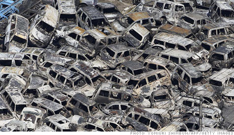
Source: Getty Images
2) Questions are being raised on the US's future in nuclear energy. Speculation is being put upon the nuclear industry as a result of the earthquake and the radiation that has been leaking from the plant, no matter how much.
3) With Haiti, Chile, and New Zealand earthquakes coming previously, there is potential for a similar earthquake in the US. As Obama has said, the United States needs to learn from this disaster and implement our own safety plan.
Nuclear energy remains a viable means of energy, however disasters such as the one in Japan scare the public.
Nuclear energy remains a viable means of energy, however disasters such as the one in Japan scare the public.
Ring of Fire
To better understand the area where these recent earthquakes in Japan have been occurring, I want to explain the Ring of Fire in the Pacific. The Ring of Fire is an area in the Pacific Ocean basin where a large number of earthquakes and volcanoes eruptions occur. The Ring of Fire, 40,000 kilometers, has over 75% of the world's active and dormant volcanoes. About 80% of the world's largest earthquakes happen along the Ring of Fire. The Ring of Fire exists as a result of plate tectonics. Two tectonic plates are sliding against each other building up stress. The earth relieves the stress by slipping violently causing earthquakes and volcanic activity.


Source: Wikipedia
The Nazca Plate and the Cocos Plate are being subducted underneath the South American Plate, which is moving to the west on the eastern side of the ring. The Cocos Plate is also being subducted beneath the Caribbean Plate. The Pacific Plate and the Juan de Fuca Plate are being subducted beneath the North American Plate. In the northern section of the ring, the Pacific plate, which is moving to the northwest, is being subducted underneath the Aleutian Islands arc and along the Kamchatka Peninsula arcs past Japan. In the south, there are a number of small plates colliding with the Pacific Plate.
For before and after pictures of Japan by moving your mouse over the picture click here.
Saturday, March 12, 2011
8.9 Magnitude Earthquake!!!

Source: Yahoo Images
Near the east coast of Honshu, Japan, a devastating magnitude 8.9 earthquake hit yesterday, March 11, 2011. This the largest recorded magnitude earthquake in Japan's history. This large earthquake was accompanyied by foreshocks on the two previous days on March 9th with a magnitude 7.2 event approximately 40 km from the 8.9 magnitude earthquake, and continuing with 3 earthquakes greater than magnitude 6 on the same day. Scientists say that this Honshu earthquake was 8,000 times the size of last months Christchurch earthquake (See previous post).The location of these earthquakes is along the Japan Trench subduction zone. The Pacific plate thrusts underneath the North American plate where Japan is located.
Large magnitude earthquakes in the area have occurred before. This zone has had nine events of magnitude 7 or larger since 1973. A magnitude 7.8 earthquake about 260 kilometers to the north of the March 11 event, in December 1994, which caused 3 fatalities and almost 700 injuries. In June of 1978, a magnitude 7.7 earthquake 35 kilometers to the southwest caused 22 fatalities and over 400 injuries.
Tsunamis were a result of these large earthquakes. A 23 foot tsunami off the coast of Japan was triggered with more than 50 aftershocks, many of them greater than 6.0 magnitude. Waves reached speeds up to 500 miles per hour! Hours later, 7 foot tsunamis reached Hawaii. Evacuations were order on Hawaii and the west coast of the United States. Ships, cars, homes were carried away by these tsunamis. Fires ignited and burned out of control as well.

Source: Yahoo Images
So far, it is predicted that greater than 10,000 people have died. Police also said 947 people were injured (Yahoo News). It may be awhile until rescuers can reach certain areas because of the damage to the roads.
Another result of the earthquakes is a nuclear crisis. An explosion occurred at the nuclear power plant in Japan. The cooling system of the plant failed, so water was poured over the reactors to cool them. The hydrogen formed from the water reacted with the oxygen, causing the explosion and radiation being emitted from the plant.
CBS video
Did they see these earthquakes coming? Could the fatalities been prevented???
There are theories out there that say that the unusual lack of seismic activity in the area may predict that there will be a large magnitude earthquake. Others say that the foreshocks were indications of the event.
Russian scientist Yevgeny Rogozhin has said that the Japanese quake could have been predicted. He said that a weaker quake took place in the area a week ago. Pre-cautions should have been taken, however hindsight is 20/20.
Friday, March 11, 2011
Christchurch, New Zealand

Source: PerthNow
As many of you have heard, there was an earthquake in Christchurch, New Zealand last month (February 21, 2011). The magnitude of the earthquake was a 6.3, however it did more damage than expected for a 6.3 magnitude earthquake because because it was so shallow. The earthquake occurred at only a 5 kilometer depth (3.1 miles). USGS website. The shallower the earthquake the more intense the damage will likely be. The waves produced by the rupture of the earth have less of the earth to travel through and . The earthquake did not last very long, however it caused a great amount of damage.Ground liquefactions caused a significant amount of the damage that occurred as a result of this earthquake. Ground liquefaction occurs in saturated soil. The soil looses strength and stiffness as a result of excess stress caused by the earthquake. This causes the soil to behave like a liquid and flow freely like quicksand.
The map below, shows where the earthquake was felt the most. The red areas, had the highest intensity and saw the most damage.

Source: USGS
Those who are responsible for planning construction of buildings in the area did a poor job. They did not expect to experience large magnitude earthquakes such as last month, and therefore did not plan accordingly. Less damage would have been done if buildings were prepared for experiencing earthquakes.
For more information and the original article click here
Subscribe to:
Posts (Atom)