Wednesday, May 4, 2011

Why so many earthquakes?

Here is a video discussing the topic of the the cluster of earthquakes that have been happening in the past 6 years.  


This will be my last post, as the semester has come to an end.  I want to thank those of you have been following the blog.  This blog has helped me learn the best ways to communicate with different audiences.  I hope that you have taken something from my posts.  Enjoy!

Tuesday, May 3, 2011

Mississippi Levee Breached = Missouri Farmland Flooded

The U.S. Army Corps blew up a levee to flood 130,00 acres in Missouri starting last night.  The result was the flooding of rich farmland.  The reason behind breaching the levee was to bring down the river levels and save the city of Cairo, Illinois as well as other communities.

The decision to breach the levee appears to be working.  The Ohio River at Cairo peaked at 61.72 feet just before the blast.  By 6 a.m. this morning, the level has dropped to 60.62 feet.  The previous recorded for the river was 59.5 feet in 1937, which is still less than what is was this morning.  The breach could cause river levels to fall by three to four feet over the next few days, according to Maj. Gen. Michael Walsh, commander of the Corps' Mississippi River Valley Division.  The city of Cairo's residents were ordered to evacuate because of the induced flooding.


Source: CNN


Missouri took the Corps to court over the intentional breaching of the levee.  The state argued that the flooding would deposit silt over the 130,000 acres of productive farmland.  The silt would take years to clear.  The U.S. Supreme Court refused to interfere, making it possible for the Major General to blow the levee.  Maj. Gen. Walsh stated that the fate of Cairo was one of many factors in his decision.  Water levels and flooding have hit record highs in many spots, putting strains on systems meant to prevent uncontrolled floods and the resulting loss of life and property.  


The breaching of the levee, I think was necessary action.  The damage caused by not breaching the levee would significantly outweigh the damage caused by breaching the levee.  


A video can be found of the blasting by following this link Click here

Global Seismograph Network Completed

The Global Seismograph Network is a network of 150 monitoring stations, globally distributed to collect information about earthquake activity. The final station was recently installed in Sharjah, near the Zagros Fault, the boundary between the Arabian and Eurasian plates.  This network provides free, realtime, open access to data and information on earthquake locations, earthquake hazards mitigation, and earthquake emergency response.  Below is a map of the location of these 150 stations.
Source: IRIS

Within hours of the earthquake, that data is automatically collected and made available through the Internet.  The Global Seismograph Network is a took that makes it possible to explore the Earth's interior and to mitigate earthquake hazards. Not only this, but it also addresses the needs of society.  

Would you ever bomb a volcano?

Bombing a volcano seems like at crazy idea at first, but after you think about it can be a successful mitigation technique for diverting lava flow.  Picking the right place to bomb is essential though.  The depth of the magma center also has to be considered.  Magmatic systems are kilometers below the Earth's surface.  However, bombing of a volcano could also prove to be insufficient and cause the volcano to erupt, rather than prevent it.  The United States have been involved in some examples of bombing a volcano.  Three times in Hawaii and once in Italy at Etna.

In 1992, Mt. Etna began erupting.  The lava was threatening some important structures on Etna, so it was decided that the lava would try to be diverted from the town.  Earthen barriers were constructed to keep the lava from flowing into the town.  Concrete blocks were also dropped on the lava flows in attempt to divert the lava.  The plan included blowing a hole in a lava tube at high elevations and then fill the lava tube with concrete blocks to stop the flow of lava in the tube. (See Figure below).  This attempt was successful in sparing the towns, but some still debate if diverting lava flows at Etna by bombing a volcano is a good idea.

Earthen barriers attempt to divert lava flows from Etna in 1992.  Source: Big Think

Concrete blocks dropped at Etna during 1992 eruption.  Source: Claude Grandpey

Another example is Mauna Loa in Hawaii.  Targeted bombing campaigns on vulnerable parts of a volcano,  mainly spatter cones that are the source of lava tubes high on the slopes of Mauna Loa, might cause sufficient diversion as to prevent lava flows from reaching the town of Hilo on the big island (Lockwood and Togerson, 1980). The first attempt to bomb Mauna Loa in Hawaii was in 1935, some of the bombing was caught on video shown here.  A second attempt in 1942, was done on Mauna Loa.  Both attempts did not provide noticeable results.  

In the 1970s, tests were performed by the U.S. Air Force and Hawaiian Volcano Observatory (HVO) scientists to see what might be the most effective means of bombing a volcano. These tests were on an older lava field with no active lava flows and were performed using relatively modern military supplies. It was found that if you target spatter cones that feed lava tube systems, then lava flow disruption occurred where the surface was most fragile and not dense, solid rocks like above some lava tubes. Bombing the actual lava tubes or flow levees didn't seem to be very effective (Lockwood and Togerson). 

Bombing the lava flow to divert it, is a relatively low cost, especially if you look at the cost of lava flows reaching the populated area.  The result of the bombing, if successful, is very effective, however, not all eruption of volcanoes will have vulnerable spots that are obvious to bomb if that was decided and could have unintended effects.   

Monday, May 2, 2011

Soil collapse after Japan earthquake

Severe liquefaction and shift in soil occurred as a result of the 9.0 earthquake in Japan this year.   As a reminder from one of my previous posts, the processes of liquefaction temporarily changes sand from a solid to a liquid state causing piles of sand to erupt on the surface.  Japan's liquefaction occurred over hundreds of miles.  This surprised experienced engineers.

Questions about whether existing building codes in other vulnerable locations here in the United States are adequate since the levels of liquefaction were higher than expected in Japan.  Hopefully we will learn something from Japan and be able to mitigate risks in other similar events.  


"We've seen localized examples of soil liquefaction as extreme as this before, but the distance and extent of damage in Japan were unusually severe," said Scott Ashford, a study team member from Oregon State University.


It is speculated that the long duration of five minutes of the Japan earthquake, is the key to severe liquefaction.  This may force researchers to reconsider the extent to which liquefaction is possible.  The age of the sediments is another factor the extent of liquefaction.  Younger, clean sediments cause higher liquefaction.  Shallow groundwater contributes to a higher level of liquefaction.  


Engineers can apparently still be surprised....
Soil sank nearly 3 feet.  Source: msnbc.com


Click here for the article.

2010 in review

Here is a fact that may make shout "Jiminy Cricket!"...almost 300 million people were affected by natural disasters in 2010!
Here is a list of the more major disasters in 2010:

  • Haiti-earthquake
  • Chile-earthquake
  • Iceland-Eyjafjallajökull volcano spewing ash
  • Russia-wildfires
  • Pakistan-flooding
  • China-flooding
The article that I read was concerned with the response due to some of these disasters and how the US communicated them.  For example, 130 million Chinese alone were affected by the worst flooding in recent history.  However, the floods received very little international attention.  Far less than either Pakistan and Haiti, which combined, was five times less than the amount of people affected by the flooding in China.  The article points out that one of the dilemmas in response to natural disasters, is that even major ones, receive significantly diverging media coverage (Ferris, 2011).  Very little international assistance was given or requested in response to the flooding in China.

This article suggests a lack of good science communication.  Response to natural disasters should not vary so much as the example, especially when China was a very significant disaster.  I think that part of reason why the flooding in China was not well communicated is that China is a different government than the United States and most other countries and didn't want to speak much about the event with them.  They are very independent.  This is just a speculation however.  

Sunday, May 1, 2011

21 quakes in 24 hours


Source: Google Images
The Taal Volcano in the province of Batangas (Philippines) has been very active recently.  It is one of the most active volcanoes in the country.  Taal volcano is unique because it has a lake inside its crater called Crater Lake. State volcanologists recorded 21 volcanic quakes in one day on the 18th of last month.  The magma has been rising toward the surface, carbon dioxide is being released in Crater Lake, and this increase in seismic activity have caused alarm.  The water temperature of Crater Lake has also increased.  It is being said by The Phillippine Institute of Volcanology and Seismology (Phivolcs) that sudden hazardous steam-driven explosions may occur and high concentrations of toxic gases may accumulate, so three sites are off limits.  These high concentrations of gases are harmful to humans and animals and can be lethal, as well as damage vegetation.  Permanent settlement on the island is strictly not recommended.

Source: explorevolcanoesnow.com
The number of earthquakes have increased.  From 9 earthquakes on April 15 to 21 on the 18th!  Officials have done a good job of recognizing the signs of an eruption and have evacuated residents.  We'll see when it erupts...

Landslide in Saint-Jude Quebec

Source: Canadian Press.  A landslide last year taken May 11, 2010

The above photo was taken a little less than a year ago in Saint-Jude Quebec.  Now there are signs that another landslide in the area may occur.  Nine families are waiting to hear if they can return to their homes, after a riverbank collapsed last Wednesday.  A large section off the Salvail River eroded and collapsed into the water.  Officials are taking precautions in order to avoid another disaster as last years landslide resulted in a family of four that died.  

So what are these signs that are predicting another landslide?

Over the past week heavy rains have caused the ground to be less stable.  The ground in the area overlies a clay seabed where water can get in between the clay particles.  Water in between clay particles = unstable.  The soil becomes weak, even worse if there are buildings providing a load on it.

It makes you wonder why homes were ever built on this clay layer in the first place.  Testing is usually done before houses are even constructed to know the types of material the foundation is going to be built upon.  These homes have probably been there a long time and testing was not available when they were being built. Now a days, homes would not be built without having lab tests done on the soil. 

Municipal and provincial officials will spend the next two months assessing the safety of the area and mitigating the erosion problem along the Salvail River.  To stabilize the shore will take six to eight weeks.  

To read the original article click here

Wednesday, April 13, 2011

Liquefaction

"When sediments liquefy, they lose their structure and strength. During earthquake shaking, the individual grains of sand within a deposit collapse on each other. Anything built on them can sink or collapse. Picture a container of balls of slightly different sizes–baseballs, golfballs, marbles. If they were transported by water into the container and then deposited, they would settle with spaces between them. Some of the spaces would be filled with water, some with air. When you shake the container, the balls settle against each other, and the water and air are forced to the surface. That is exactly what happens in a sediment-filled valley. The valley is a large ‘container’ holding gazillions of ‘balls’ or grains of sand. Shaking the container simulates an earthquake" (Science Views).
Source: Science Views
This video shows how and why houses get damaged or collapse during an earthquake in a seemingly stable geologic environment.
The following observations were made:

  • The water works its way to the surface, flooding the area around the houses,
  • The "houses" start leaning over and sinking into the sand, and
  • The volume of the sand decreases by a small amount.

Friday, April 8, 2011

Another Aftershock for Japan

Areas are still flooded from the tsunami near Sendai, Japan and yet another aftershock it the east coast of Japan, 40 miles from Sendai, knocking out the power in the northern part of the country on Thursday morning.  It was orginally measured to be a magnitude 7.4 but was downgraded by the U.S. Geological Survey in Golden to be a magnitude 7.1 aftershock of the 8.9 earthquake.  It is the strongest aftershock since several were recorded on March 11.  Another two were killed as a result of the aftershock and over a 100 injuries were reported.  A tsunami warning was issued following the quake, but was then taken off and announced that there was no tsunami threat to Hawaii.

The operator of the Fukushima nuclear power plant said there was no sign that any more damage was done.  The plants spent fuel pools lost cooling capacity briefly when the power went down, but resumed shortly after just the way it was supposed to work.  There is no evidence of any radiation to have leaked so far.  It is constantly being monitored right now.  Japan cannot afforded to have more destruction to its nuclear power plant.

Thursday, April 7, 2011

I-70 High Maintenance

Close to home, I-70 near Georgetown was closed this last Tuesday due to mitigation of rockfall hazard.  Rock scalers were working for seven hours prying unstable boulders from the rock outcropping 300 feet above the highway near Georgetown.  To loosen the rock, the Colorado Department of Transportation (CDOT) used high-pressure airbags as well as other devices.  The boulders were caught in netting that was strung across the slope of the Georgetown Grade.  Georgetown Grade gets a significant amount of attention because of the heavy traffic volumes on I-70 below and it has an especially high slope that can send rocks down a long distance, building energy and momentum as it goes.


Source:Denver Post

For a short video that shows rocks being scaled click here

Scaling is done periodically to help reduce the risk of rockfall coming onto the highway.  By closing the highway and prying these boulders out, they will no longer be taunting I-70 commuters below.  About 30,000 motorists drive along I-70 at Georgetown Hill every day.  In 2003, a commuter was killed when a boulder crashed into his windshield.

After working on the site, CDOT announced that another rockfall mitigation technique may need to be done in the coming weeks.  Anchoring boulders may be done, if a solid section of the slope can be found.  This would mean another lengthly closure of I-70.

CDOT has placed netting along the slope face.  The goal of these nets is to progressively slow down falling rocks by letting them slip through the netting and roll to the next fence.  The rocks will loose energy this way each time they hit the netting.

The full article can be find here: I-70 reopens near Georgetown; intermittent closures planned Wednesday

Monday, April 4, 2011

China Maps Active Faults

The Chinese government has announced it launched a campaign to map its country's active faults as a result of the strong earthquakes in Japan and Myanmar.

The reason for this being that earthquakes mostly occur on or near active faults.  China has faults that run tens to thousands of kilometers in length.

The CEA Institute of Geophysics has said that China is working on a new seismic map which would mark the different regions by the risk of a quake.  They have said the map will be finished this year.  Based on this new map, the government will have specific requirements for buildings and other facilities across the country.

You may be wondering if Japan was pursuing mapping their active faults within their own country?  Japan has already mapped the seismic risk of different regions. They are considered to be very well prepared for earthquake activity with codes for buildings and other infrastructure already in place.  However, I still find it quite scary that if an earthquake happens at the country's capital of Tokyo, it will hit one of the most densely populated city in the world.

It is encouraging that China is taking action to be better prepared for earthquakes in their country.

Wednesday, March 23, 2011

California updates plans for tsunami danger

Damages along the Californian coast have reached up to $50 million.

Scientists at the California Geological Survey (CGS) are visiting every port city along California's coast to detail the affects of the tsunami that hit the coast as a result of the March 11 earthquake in Japan.


Rick Wilson, and engineering geologist for the California Geological Survey has said, the CGS is now planning maps to help land-use planners assess hazards to buildings near shores and harbors as well as provide a guide to danger zones where new construction might be avoided.  The new maps will not be ready for a year or two.  The maps are primarily based on a worst case scenario of a 9.2 magnitude earthquake in the Aleutian Islands (Alaska).

Read more: http://www.sfgate.com/cgi-bin/article.cgi?=/c/a/2011/03/21/BAR51IG6NE.DTL#ixzz1HSC1rchY


New evacuations plans are also being developed for future tsunamis.

It is good to know that we are learning from this disastrous event so that we can be better prepared in the future.

We're Sinking....

Foundation and walls cracking....water leaking through windows....

These are a few signs that people whose houses are built on sinkholes are seeing in Florida.  The land below their houses in sinking.  Some home owners are saying that their house will sink in before it will be fixed.  There is a major debate going the the Florida legislature right now to find out when insurance companies should pay for sinkhole damage.  For more information about the insurance companies seeking legislation to reduce sinkhole claims click here.

What is a sinkhole?
A sinkhole is a hole or depression in the earth's surface often associated with glacial terrain.  Sinkholes can vary in size from about 3 meters to 600 meters.  They can form gradually or can occur suddenly in rocks that naturally be dissolved by water circulating through them.  This creates voids in the rock that can cause the rock to collapse.  Many processes can lead to sinkholes.  Erosion, lowering the level of groundwater, or the collapsing of a cave can all lead to the formation of sinkholes.

Picture of a sinkhole

Check out this video catching the some of a sinkhole collapsing in Texas in 2008.

Federal $ to Foreign aid

Recently I have been surfing the internet and have constantly been seeing links to donate to the people of Japan.

As a nation, should we be putting money into foreign humanitarian aid, when poverty and humanitarian issues exist at home?  Has New Orleans been fully rebuilt?

How much should be spent aboard and where do you draw the line?  In 2010, Haiti received over $30 million US aid.

Obama has called for Americans to donate to the cause in Japan, in the media.  This is someone's personal choice, but when federal dollars are sent to be spent on aid, everyone has to pay.

Tuesday, March 22, 2011

Haiti compared to Japan

Haiti compared to Japan:


The 2010 earthquake in Haiti had a magnitude 7 compared to Japan's 8.9 magnitude earthquake, which released more than 1000 times the energy than what occurred in Haiti.  However, more than 200,000 people were killed in Haiti compared to the greater than 10,000 in Japan just recently, as a result of the earthquake.  The reason why so many were killed in Haiti was because Japan was prepared.  Japan is one of the most earthquake prepared countries, while Haiti was far from being prepared.

Haiti 2010 earthquake.  Source: Google Images

Japan 2011 earthquake.  Source: Kyodo/Reuters
Japan invests research into understanding the processes of earthquakes and creates infrastructure that is better  to withstand effects.  You can see in the above two pictures that most of Japan's buildings are still standing, compared to the infrastructure in Haiti, where the buildings are collapsed or soon will be.
They also have an adequate warning system in place.  Seismic networks that record waves in the earth, provide a tsunami warning system and an earthquake warning system that can gives tens of seconds warning.
Haiti, however does not have the money that Japan does to invest in earthquake prevention.  Unfortunately, Haiti has virtually no building codes.  The primary cause of deaths as a result of the earthquake in Haiti was the collapse of buildings that where not built to survive a strong earthquake. 

How Does the Japan earthquake affect the US???

The earthquake in Japan was a devastating event both economically and socially for their country.  It also affects the rest of the world, including the United States as well. 

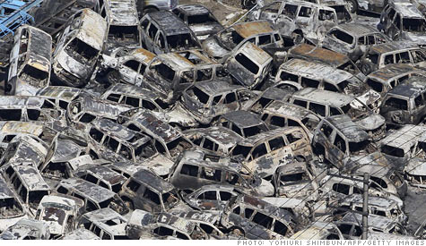
1) One result of this disaster, is that we will see car prices going up.  Cars that were ready to be exported are seen below.

Expect car prices to rise as the effects of Japan's earthquake and violence in Libya begin to be felt. In this image, cars that had been ready for export are piled up in a Japanese port.
Source: Getty Images
2) Questions are being raised on the US's future in nuclear energy.  Speculation is being put upon the nuclear industry as a result of the earthquake and the radiation that has been leaking from the plant, no matter how much.

3) With Haiti, Chile, and New Zealand earthquakes coming previously, there is potential for a similar earthquake in the US.  As Obama has said, the United States needs to learn from this disaster and implement our own safety plan.

Nuclear energy remains a viable means of energy, however disasters such as the one in Japan scare the public.

Ring of Fire

To better understand the area where these recent earthquakes in Japan have been occurring, I want to explain the Ring of Fire in the Pacific.  The Ring of Fire is an area in the Pacific Ocean basin where a large number of earthquakes and volcanoes eruptions occur.  The Ring of Fire, 40,000 kilometers, has over 75% of the world's active and dormant volcanoes.  About 80% of the world's largest earthquakes happen along the Ring of Fire.  The Ring of Fire exists as a result of plate tectonics.  Two tectonic plates are sliding against each other building up stress.  The earth relieves the stress by slipping violently causing earthquakes and volcanic activity. 


The Figure below shows the tectonic plates in the region.

Source: Wikipedia

The Nazca Plate and the Cocos Plate are being subducted underneath the South American Plate, which is moving to the west on the eastern side of the ring.  The Cocos Plate is also being subducted beneath the Caribbean Plate.  The Pacific Plate and the Juan de Fuca Plate are being subducted beneath the North American Plate.  In the northern section of the ring, the Pacific plate, which is moving to the northwest, is being subducted underneath the Aleutian Islands arc and along the Kamchatka Peninsula arcs past Japan.  In the south, there are a number of small plates colliding with the Pacific Plate.
For before and after pictures of Japan by moving your mouse over the picture click here.

Saturday, March 12, 2011

8.9 Magnitude Earthquake!!!

Source:  Yahoo Images

Near the east coast of Honshu, Japan, a devastating magnitude 8.9 earthquake hit yesterday, March 11, 2011.  This the largest recorded magnitude earthquake in Japan's history.  This large earthquake was accompanyied by foreshocks on the two previous days on March 9th with a magnitude 7.2 event approximately 40 km from the 8.9 magnitude earthquake, and continuing with 3 earthquakes greater than magnitude 6 on the same day.  Scientists say that this Honshu earthquake was 8,000 times the size of last months Christchurch earthquake (See previous post).

The location of these earthquakes is along the Japan Trench subduction zone.  The Pacific plate thrusts underneath the North American plate where Japan is located. 

Large magnitude earthquakes in the area have occurred before.  This zone has had nine events of magnitude 7 or larger since 1973. A magnitude 7.8 earthquake about 260 kilometers to the north of the March 11 event, in December 1994, which caused 3 fatalities and almost 700 injuries. In June of 1978, a magnitude 7.7 earthquake 35 kilometers to the southwest caused 22 fatalities and over 400 injuries.

Tsunamis were a result of these large earthquakes.  A 23 foot tsunami off the coast of Japan was triggered with more than 50 aftershocks, many of them greater than 6.0 magnitude.  Waves reached speeds up to 500 miles per hour!  Hours later, 7 foot tsunamis reached Hawaii. Evacuations were order on Hawaii and the west coast of the United States.  Ships, cars, homes were carried away by these tsunamis.  Fires ignited and burned out of control as well.

Source: Yahoo Images


So far, it is predicted that greater than 10,000 people have died. Police also said 947 people were injured (Yahoo News).  It may be awhile until rescuers can reach certain areas because of the damage to the roads.

Another result of the earthquakes is a nuclear crisis.  An explosion occurred at the nuclear power plant in Japan.  The cooling system of the plant failed, so water was poured over the reactors to cool them.  The hydrogen formed from the water reacted with the oxygen, causing the explosion and radiation being emitted from the plant.

CBS video

Did they see these earthquakes coming?  Could the fatalities been prevented???

There are theories out there that say that the unusual lack of seismic activity in the area may predict that there will be a large magnitude earthquake.  Others say that the foreshocks were indications of the event.
Russian scientist Yevgeny Rogozhin has said that the Japanese quake could have been predicted.  He said that a weaker quake took place in the area a week ago.  Pre-cautions should have been taken, however hindsight is 20/20.

Friday, March 11, 2011

Christchurch, New Zealand

Source: PerthNow
As many of you have heard, there was an earthquake in Christchurch, New Zealand last month (February 21, 2011).  The magnitude of the earthquake was a 6.3, however it did more damage than expected for a 6.3 magnitude earthquake because because it was so shallow.  The earthquake occurred at only a 5 kilometer depth (3.1 miles).  USGS website.  The shallower the earthquake the more intense the damage will likely be.  The waves produced by the rupture of the earth have less of the earth to travel through and .  The earthquake did not last very long, however it caused a great amount of damage.

Ground liquefactions caused a significant amount of the damage that occurred as a result of this earthquake.  Ground liquefaction occurs in saturated soil.  The soil looses strength and stiffness as a result of excess stress caused by the earthquake.  This causes the soil to behave like a liquid and flow freely like quicksand.
The map below, shows where the earthquake was felt the most.  The red areas, had the highest intensity and saw the most damage.


Source: USGS

Those who are responsible for planning construction of buildings in the area did a poor job.  They did not expect to experience large magnitude earthquakes such as last month, and therefore did not plan accordingly.  Less damage would have been done if buildings were prepared for experiencing earthquakes.

For more information and the original article click here

Wednesday, February 23, 2011

Massive iceberg breaks off after a New Zealand Earthquake

Yesterday a 6.3 magnitude earthquake hit New Zealand causing a large iceberg to shear off a glacier!  The iceberg, estimated to weigh 30 to 40 million tons, then landed in a lake causing waves up to 3 meters high.

Potential Earthquakes in Eastern US

Have you ever experienced the ground shaking from an earthquake?  Scientists are concerned that there is a potential for a major earthquake in the future of the Mississippi Valley.  This area is the New Madrid seismic zone. Severe ground shaking would occur in areas such as Memphis and St. Louis.  It has been brought to the media's attention because some scientists believe that the stress on the Earth in this zone has been decreased and therefore the zone is being shut down.


Source: USGS
The evidence for this predicted earthquake is based on decades of research in the area. They have found evidence from the geologic record and Global Positioning System (GPS) data.

In the years of 1811-1812, 3 major earthquakes were recorded of magnitudes 7.7, 7.5, and 7.7.  For more information on what these magnitudes mean click here.  These past earthquakes are a good indication that there will be more in the area.

Research shows that there will be large future earthquakes in the area and people should be prepared.  Building codes are required to help lessen the blow of a major earthquake on both public safety as well as potentially decreasing the economic strain in the region after an earthquake occurrs.  People need to be aware of this high potential hazard as well.
To gain more information you can read the following article: Earthquake Hazard in the New Madrid Seismic Zone

Wednesday, February 9, 2011

Landslides in Brazil

Friday, January 14, 2011 Source:AP

Last month, north of Rio de Janero in Brazil was overcome with mudslides that seems to have been triggered by heavy rainfall.  It is being said that this is the greatest natural disaster in Brazil's history.  It is estimated that greater than 1300 people were killed in these landslides and severe flooding.

Mudslides outside Rio de Janero, Brazil Source: The Seattle Times

Houses being built in the areas where these landslides occurred also contributed to the slides by putting more force on the unstable earth.  This goes to show that there needs to be studies done before constructions of houses or buildings are built.  These engineering studies should show that the land was not stable and houses or other buildings probably should not have been Other techniques besides aviodance include building a wide range of barriers at the bottom of the slopes.  There are three main ways to help stablize a slope including:
- Changing to shape of the slope
- Lowering the level of the groundwater or lowering the amount of water present in the earth material by drainage
- Mechanical methods such as barriers or anchors (see the picture below)

Stabilizing the slope.  Source: The full wiki.
For more pictures of the flooding and landslides in Brazil: Disasterous photos from 2011 Brazilian landslides

Monday, February 7, 2011

How will they study?

University of Buffalo's campus where the Geological Hazards Facility will be built.
As mentioned in my previous post, pyroclastic flows are unpredictable and therefore are hard to get measurements on.  You can not set up measurements in a pyroclastic flow in a controlled way; where the conditions that cause pyroclastic flows are known.  Some methods are being developed that would allow measurements to be taken from a distance.  However, when tested on a live volcano, we don't know the what source of the pyroclastic flow was like, what the initial  velocity was, or any information on the inner structure of the flow. So how then will the future Geologic Hazards Facility study these flows using experiments?  
The experimental field station will model pyroclastic flows on a scale large enough to illustrate most of the physical processes.  By being in control of the conditions, the instruments needed to take accurate measurements could be set up along the path of the flow.  Measurements could also be taken from a distance just as in a real volcano but now there will be additional information.  

Wednesday, February 2, 2011

Blog Self Interview

What is the purpose of this blog?
The purpose of this blog is to become a better writer by communicating science effectively.  I would also like to inform readers about what type of geological hazards are going on in the world today. 

Who is the imagined audience(s) of this blog?
The imagined audience is those not in the science field. 

Have my posts matched up with my purpose/audience?  What/Who might I be overlooking in defining my purpose/audience this way?
I think that I still have improvment to be made with this.  I want readers to be able to understand what I am trying to get across and still find it interesting.  I may be overlooking those who are in my same field, and would like updates on news that is going on in our field.

What can I do to encourage more reader participation with my blog?
I think changing the tone so that it is not always scientific would encourage readers to participate.

How can I expand my audience in this class?  Outside of this class?
Posting on a wide range of subtopics would get more peoples interest both inside this class and outside.

How would I characterize the tone of my blog?
I would charcterize the tone of my blog right now as serious and scientific.  I hope to change this and be able to lighten the tone up as part of my posts.
What do I hope to get out of writing this blog?
From this blog I hope to be able to engage readers and keep them interested in my topic.  Science communication is difficult to grasp and I hope that I can get better at this by keeping to write.
What would I like others to get out of it?
I would like others to gain some knowledge of geological hazards so that they can be more informed when these events happen.
What are the strengths of my blog/my blogging?
I think that a strength of my blog is that they are easy to read.
What are the weaknesses?
One of my weaknesses in my blogging is that I need to provide more information with my posts.  Readers are left with questions after reading them.  I hope that I can improve on this weakness.  Another weakness is that there could be more pictures and links for readers to click on to get more detailed information.
Have I used a deficit model in my writing, or something else?  How would I know?
I think that there is some deficit modeling in my posts and then not in others.  One way to know, is the comments that people have left about my posts.
How have I characterized (implicitly or explicitly) science, engineering, and/or technology in my blog?
I have characterized science and engineering as mostly explicitly in my blog.
 
How have I characterized myself?
I characterize myself as someone who wants to learn new information in my field and wants to share it with others.

Self Evaluation

I think that I have been posting a good amount of posts.  I have tried to post at least two a week.  My posts have been on events or news that have been happening recently in the world of geology and geologic hazards.  I have stayed focus on my topic of geological hazards as well as trying not to use jargon so that a wider audience can gain from my blog.  I have also been reading the comments that other people have left on my posts, and I feel I have done a good job responding to them, taking the advice and answering questions that they have.  I have also tried to post pictures so that the posts are not boring and links so that more information can be found easily.

Feedback on Science Communication Readings

Our class has been assigned to do some readings to better understand how to communicate science efficiently.  One reading that has had an impact on how I will blog is section 2.2 from Investigating Science Communication in the Information Age (Holliman, Whitelegg, et al.).  I found myself thinking of ways that I could engage the public.  How communicating with readers should help them be interested in science.  I am going to try and accomplish this with my blog about geological hazards.  I want the public to care about these hazards.

Section 2.2 mentions that the public understanding of science program did nothing to improve peoples understanding.  The publics education was the same after 10 years of the program.  Researchers analyzed why the program did not have an impact and came up with several ways.  The first one being that the program was too simplistic and used a "deficit model" for the public.  A "deficit model" portrays the public as ignorant of science and not capable of understanding.  Just telling people the facts about science was not the way about getting the public to understand.  The information needed to be related to the public and their opinions should be considered.  Eventhough the public may not be knowledgeable about a specific scientific topic does not mean that they are ignorant of all of science.  

Therefore, I will try to relate my topic with the public so that they have a reason to keep reading.

Tuesday, February 1, 2011

Pyroclastic Flows

Here is some more information on pyroclastic flows, which is the type of lava flow that the new facility in New York will be studying.

Pyroclastic flows are considered dangerous because they are fast moving and explosive.  They contain  hot gas and fragments of rock.  These flows can travel at speeds up to 450 miles per hour, flow downhill, may spread out laterally, and can extend for miles.  The speed of the flow depends on the slope of the ground and the size of the flow.  A cloud of ash rises above the flow that hugs the ground.

Here is a video of a pyroclastic flow, using Mt. St. Helens as an example of how unpredictable and disastrous these flows are.

Monday, January 24, 2011

New Geological Hazards Facility

A new geologic hazards facility at the University of Buffalo is going to be built within the next decade in order to study volcanic activity.  The facility is still in the planning stages at this point.  One of the first areas that the facility plans to study is on volcanic processes to help interpret the geologic record.  The study of the formation of craters and the structures beneath them could prove to yield economic resources.  Diamonds are found underneath certain types of craters!!! 

Research would also be done on pyroclastic flows.  These flows are not completely understood because the flows are explosive and unpredictable in nature.  Measurements are hard to take as a result.  The facility would study these flows with an experimental field station. 

There will be an emphasis on the study of volcanoes because there is a gap between other geological hazards experimentally.  The facility plans to broaden to other geological hazards.

Sunday, January 23, 2011

Welcome

Welcome to my blog about the importance of geological hazards!  The impacts of many different geological hazards will be looked at in order to get a better understanding of them as well as current news of landslides, rockfall, swelling soils etc.  Feel free to comment, but please keep them respective.